Segesta has two principle monuments, both a long walk up two hills, one to the left and the other to the right of the ticket booth. There is a road up to both sites (a theater and a temple), but you cannot take a car up. There is a bus, but it is infrequent and does not allow you to visit both on one trip. You need to go back down to the ticket booth and wait for a second bus. Perhaps that is why there were lots of people at the café and bookstore near the ticket booth but very few at the theater and temple.
On the long walk up to the theater you pass the Greek agora which later became the Roman forum. In the 3rd century AD it fell into ruins. There were the remains of a 12th century mosque and an Arabic necropolis which was destroyed by the Normans in the 13th century. I guess nothing changes (given the recent anti-moslem protests in Montreal) There are the remains of churches and other buildings currently being excavated; but by the Middle Ages, many of the stones had been recycled.

The theater is particularly beautiful, dug into the rock of the hill and dates from the 3rd century BC. It is quite large with a semi-circular seating area of 63 meters. The view from the top is spectacular, all the way to the Gulf of Castellamare. I walked around for several hours, not seeing anyone, but enjoying the scenery and the wonderful smell of the wildflowers and Artemisia found at all the ancient temple sites. In the summer, Segesta organizes shows and performances of Greek and Latin tragedies) which must be awesome. I would come back for that.


Outside the ancient walls of Segeste there is the Doric temple. It was built between 420 and 430 BC and is one of the most important Greek sites. It is 61 meters long and 26 meters wide, built upon 4 steps, with a total of 36 Doric columns supporting the stone roof-frame of the structure. Apparently, the temple was never completed. It also appears that the structure never had a roof and archeologists are still in disagreement as to whether the Temple was deliberately planned this way or was just never finished. I took the bus down to the ticket booth. On the way down to the ticket booth you could see the Greek temple. It was even more impressive close up. I had spent so much time at Segesta; I decided to give Erice a pass. I will try to take a trip there from Cefalu later.


I decided to drive through the Valderice Valley because I wanted to see the landscape. I loved the peaceful countryside with the aqueduct and Erice visible on top of the hill. I will have to go back when I go to Erice and spend more time exploring.

I cut across to Castellammare to save time and went along the small highway parallel to the autostrada and was beginning to enter the mountains that extended like fingers into the sea. I only got on the autostrada near Partinico. However, here I began to see what appeared to be seaside bedroom-communities for Palermo. There was also much more traffic than I was used to.
I was glad to finally get off the autostrada at Cefalu and call Luigi Arico to meet me at the gas station. He arrived in 5 minutes and led me up this small mountain road (circa 5 km) which skirted the sea with wonderful views of Cefalu to his absolutely stunning house on the side of the mountain overlooking the river (but no sea view). He took 25 years to build the house, incorporating local stone, wood, and found objects. He is an artist by trade and it shows in the small details around the house. He also has a wonderful garden which he proceeded to show me. He had stocked the house with firewood (there is a working fireplace), lemons, olive oil from his trees, and assorted cakes. He showed me how to turn on the heating, the indoor and outdoor lights and left, telling me to call him if I needed anything. I went to bed, leaving the windows open so I could hear the river and smell the freesias that were in bloom in the garden. But after weeks of damp linen in Menfi, the best thing was the dry sheets.


I woke up to the wonderful sound of roosters crowing and proceeded to explore the property. It very much looked like a “mountain cottage”. It was full of his art pieces including the “eyes” over the bed. I will not get tired of the view from the garden. I then hung all my clothes outside on the line as they were still slightly damp from Menfi. I took stock of the groceries and decided to go to the local supermarket, gas up, and then explore the roads around the house.


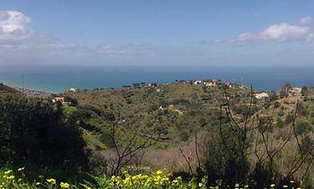
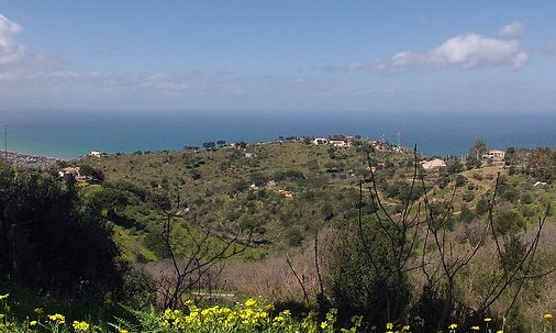
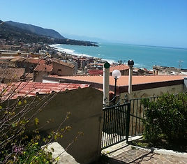
I took stock of the groceries and decided to go to the local supermarket, gas up, and then explore the roads around the house. But I first registered my position on both my Nokia (GPS lady) and on my Samsung (Google Maps). There were 5 mountain roads at the closest crossroad so I had many options. Most of the neighbouring houses were small homesteads with a few olive trees, chickens, and even a few donkeys. As I circled the mountain road I had wonderful views of the sea and Cefalu with La Rocca in the background.
After shopping I drove back to the house but could not find it. I used both GPS devices. Both brought me to the same place and said I was 1 minute (walking) away. But, I did not see the driveway. I kept driving up all the mountain roads in circles. I finally went to a nearby church and phoned Enrico to come and find me. He was glad to come, saying he had to plant his garden peas anyway. It was only when I looked at the map on my Nokia that I understood what was happening. The road Contrada Campello is a long road that zigzags from the top of the mountain to the sea. The switchbacks are very tight and both GPS devices had recorded my position on an upper loop (I guess they intended me to scramble down the extremely steep slope) to the driveway. I was at the red asterix not the white star! Now that I know, I won’t get lost. After dinner, the winds really picked up and there was a huge mountain storm. I could barely see the lights from the Sanctuary across the valley.
What a gorgeous day after the rain and tremendous winds yesterday. I started by trying to catch up on my writing but the sunshine and bird song tempted me outside. I had breakfast in the outside kitchen. It was so hot I had to change to summer clothing and then left to explore some of the small mountain roads where I got lost yesterday. I took the road up to Pozzo Maria - a newish area where lots are for sale. Wow what lots! On one side you see the ocean and on the other side the mountain. The villas are new but fit into the landscape. I think any construction requires prior approval of the plans. The main road through the hamlet is signposted with the “stations of the cross”.
I then drove down to Cefalu to gas up (I don’t want to be stuck in the mountain without gas) and to buy stuff for a picnic lunch. After gassing up I headed for the Sanctuary at Gibilmanna that I can see from my house. The road was wonderful, full of switchbacks and very little traffic. Whenever you were pointing in the right way, you could see snow on the mountains. The sun was very hot, but the wind coming off the mountain was chilly. The car smelled of the ripe local strawberries I had bought for my picnic.


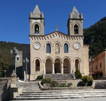
I arrived at the Santuario di Gibilmanna, dedicated to the Madonna, just as the bells were ringing. The Santuario di Gibilmanna, built in the 6th century, sits on top of Pizzo San Angelo. It can be seen for miles, especially when lit up. Its name derives from the Arabic for mountain and manna (see below). It is surrounded by oak and chestnut forests-it must be delightful in the summer heat. I was the only person there so I sat under a tree in the shade and had my picnic of Sicilian bread, cheese, salami, and local strawberries. I walked around the grounds and admired the views of the forest and sea.
I then took the mountain road to Castelbuono, the self-declared capital of the Monti Madonai. Castelbuono is known for its production of “manna”, the sap of the south European flowering ash (Fraxinus ornus). It has many culinary and medical uses, including (according to locals) bringing the dead back to life. I will bring some back (you never know…).
Castelbuono is a great town – it proudly declares itself a nuclear-free zone. According to the guide book, it removed all the garbage trucks a few years ago and replaced them with donkey-drawn carts. I cannot attest to this since I did not see any. I stopped for a cappuccino and had a long conversation with the barista who knew of Montreal because one of his friends plays soccer for the Impacts. Apparently all the citizens of Castelbuono are Impact fans. I walked around and took pictures of the charming laneways, churches, and squares which still had water fountains for people to collect drinking water. Many Sicilians collect all their drinking water from these natural springs. Most of the ground water in Sicily is safe to drink without any treatment.


I then returned home to dinner and continued reading by the fireplace. I had thought my impressions of Sicily were unique. But I read this quote in the Leopard “they turned up a slope and found themselves in the immemorial silence of pastoral Sicily. All at once they were far from everything in space and more in time.”
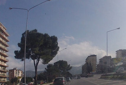
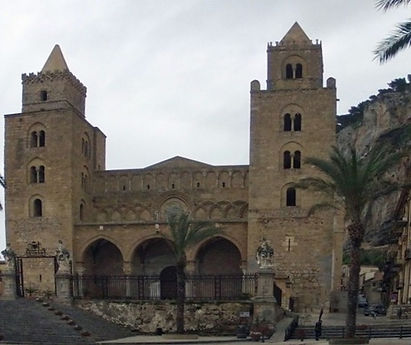
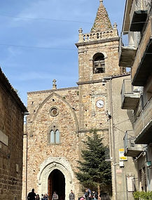
Thursday morning, it was cloudy and windy so I decided to visit Cefalu. Cefalu originated as a fortress outpost attached to Himera (see below). When Himera was destroyed in 396 BC by the Carthaginians under Himilco, refuges moved to Cefalu which could be better protected. During the first Punic war in 254 BC, the Romans under Atilius Calatinus and Scipio Nasica conquered Cefalu by treachery. Strabo, Ptolemy, and Pliny all mention Cephaloedium, as it was known in Latin. The Romans were replaced by the Byzantines and the populace moved from the seashore to the top of the Rocca which gave better defense from pirates. The Arabs conquered Cefalu in 858, built a Saracen Castle on top of the Rocca, and Cefalu became part of the Emirate of Sicily. Many of the small medieval streets still have an Arabic flavour. When the Normans conquered Sicily, Roger II moved the town back to the seaport which was more accessible. He also started to build the Cathedral in 1131.
I parked on the lungomare, a long stretch of sandy beach below the town. There were staircases down to the water and a few hardy souls walking near the water. But it was way too stormy for me so I went for a cappuccino to plan my day.

I first decided to walk through some of the small streets that make up the older part of Cefalu. Unfortunately, Cefalu does not restrict cars and parking so the small streets were crowded and one had to watch out for motorcycles, zipping by. There were also many tourist shops, restaurants, wine bars, and other drinking establishments. Apparently, Cefalu has an active night life in summer.

At the end of Cefalu, there were several old apartment buildings with stairs down to a rocky beach. There was also a tiny fishing harbour and, what looked like a nice restaurant. If I lived in Cefalu, this is where I would want to be. It also seemed to be more tranquil.


I walked to an Arabic medieval wash house, the Lavatoio Medeviale, still in use until recently. The river still runs to it and you can hear the rushing water from the street. It is now, what appears to be the courtyard of a high-end restaurant – quite lovely!
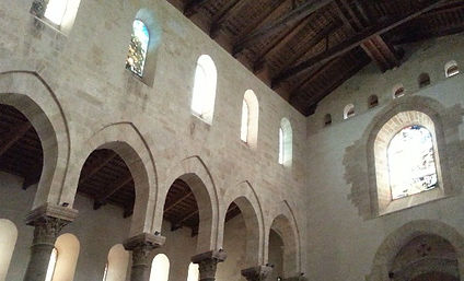
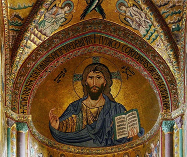
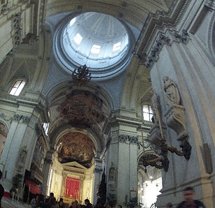
I then walked to the Piazza Duomo to see the Cathedral. The square is quite large, surrounded by the patios of restaurants and coffee bars. There are good views of the cathedral with the Rocca behind it. The cathedral is built in the Norman, Sicilian Romanesque with interlacing pointed arches and windows. It is a nice break from the Baroque. There are two massive 4-storied square towers on either side of the façade and a semicircular apse acts as buttresses. There are also attached cloisters. The inside was also lovely with a wooden ceiling and Arabic touches in some of the mosaics. I really appreciated the simple interior – having had my fill of the rich Baroque of most of the other cathedrals.
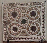

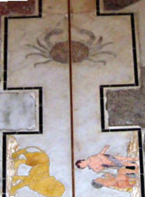
The altar with the mosaic of Christ Pantocrator gazing down dominates the cathedral when you enter. The jewel-like colours are still so bright it is difficult to believe it was created in 1148. On the side is a beaten-silver altar. I have not seen that described anywhere although, Angela my host in Melizza did comment that it was special.
I then drove home and since it was still cold and windy made a fire in the fireplace. I downloaded “The Leopard” by Tomasi di Lampadusa and began reading it in front of the fire.
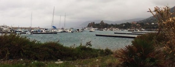
Friday, I decided to explore the port of Cefalu (since it is still a fishing port) and then to head west (towards Palermo) along the old coastal highway (SS113) that runs between Messina and Palermo. The port was charming with many boats that looked like pleasure craft rather than working boats.
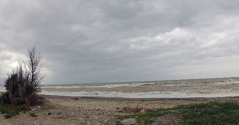
The seaside was disappointing. The Italians built the railroad along
the seaside. I guess that makes sense since it is the only flat strip; high mountain spurs from the Monte Madonai cut into the sea every 20 km or so. However, it is an eyesore. Because of the railroad this strip is also heavily industrialized. There were many abandoned old houses along the beach. They must have been great before the railroad and industries were put there.


I drove almost all the way to Termini Imerese trying to find Himera. Termini Imerese is on top of one of the mountains going into the sea (Mont Calogero). It was established in the 7th century BC and grew into importance by absorbing the survivors of Hemera when it was destroyed. It was enjoyed by the Romans for its thermal baths which are still famous in Italy. I decided to turn back because Himera is between Cefalu and Termini Imerese. I took several unnamed small roads and saw some beautiful countryside on the mountain side of the SS113.

I also took a small road towards the sea at Campofelice and saw a gated seaside community called Residence Himera. It reminded me very much of Florida with small identical pink villas set in a garden. Many looked dilapidated and several were for sale. There was no one there except some workmen cleaning up the place. I guess it is a summer residence since it is right on the Sea. I found it depressing; but maybe because of the gray day.

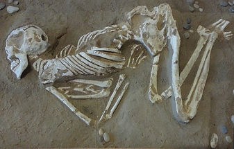
I finally stopped and asked how to get to Himera. It is very badly marked. I first visited the museum which still had some artifacts from Himera (most are at Palermo). The museum emphasizes the memory of a defeated city – with an emphasis on the necropolis and exhibits of tombs (including skeletons). There are several pieces of sculpture, many emphasizing feet. Their prize possession is a gold miniature but I cannot tell what it depicts – male or female. I was glad to leave the museum and go to the site.


Himera was founded in 648 BC by Greeks and was the first Greek settlement on the north coast of Sicily. It occupied an important position on the eastern edge of the Carthaginian territory. Solus (Soluntum) and Panormus (Palermo) were two Carthaginian colonies on the north side of Sicily. The despot, Terillus, was expelled from Himera by Theron, despot of Agrigentum. Terillus then asked Hamilcar, a Cartheginian for help. Hamilcar took the opportunity in 480 BC to mount the first expedition into Greek territory by sending an army of 300,000 men to attack Himera. Theron from Agrigento and Gelon from Syracuse defeated the vastly larger forces of Hamilcar. Hamilcar was either assassinated by a Greek spy before the battle or threw himself on a pyre after the defeat. This was a significant political event in the Mediterranean world, signaling the transfer of power from the Carthaginians to the Greeks. However, the Carthaginians had their revenge on Himera when Hannibal, Hamilcar’s nephew, completely destroyed Himera in 409 BC forcing the survivors to move to Termini Imerese.
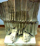
The site occupies a position between the railroad and the highway so has not been well preserved. The only monument that remains is the Temple of Victory, dedicated to Athena, constructed by the conscripted Carthaginian prisoners to celebrate the Greek victory in 480 BC.
However, the site is very evocative. I was the only person there (I think in months). The site was overgrown with thistle, raspberry canes, and wild flowers. There was no clear path; one had to force oneself between fallen stone blocks through thistle and cactus. I kept on thinking about the vipers that inhabit this region, so I made a lot of noise. I was able to walk around the perimeter (22.45 m x 55.9 m) along the top step over alyssum, blue violets and other wild flowers growing in the cracks. At one point I slipped and grabbed a raspberry bush to regain my balance and left my blood to mingle with any remaining Greek and Carthaginian blood.

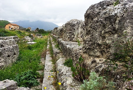
Despite, the highway (SS113) being just behind the temple (you can see the top of a crane in the picture above), it was very peaceful and I enjoyed the couple of hours I spent there. I returned home to another fire and my eBook. Luigi phoned me and asked me if I wanted to go into Palermo with him tomorrow morning. I could leave my car at the Cefalu railway station and take the train back when I was through. I said yes and arranged to meet him at the station for 8:00 AM.
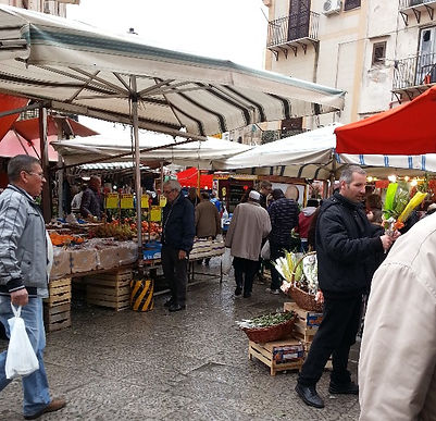
Luigi took the autostrada to Palermo so we got there very quickly. He dropped me off at the Palermo Central Station which reminded me very much of the train station in New York City. In fact, all Palermo reminded me of the Big Apple. It had the same energy, street vendors, carts selling street food, and grime. I walked down via Roma to the famous Enrico took the autostrada to Palermo so we got there very quickly. He dropped me off at the Palermo Central Station which reminded me very much of the train station in New York City. In fact, all Palermo reminded me of the Big Apple. It had the same energy, street vendors, carts selling street food, and grime. I walked down via Roma to the famous Ballaro Market and bought some local fresh peas. I did not haggle. The fish looked great but I did not want to carry it to all the places I intended to visit. and bought some local fresh peas. I did not haggle. The fish looked great but I did not want to carry it to all the places I intended to visit.

Palermo occupies a beautiful site between Mount Pelegrino and the fertile Conca d’Oro valley to the south and a large bay to the north. It was first occupied by paleolithic Sicani settlers in 8000 BC, as evidenced by the cave art from Addaura. In 734 BC the Phoenecians (seagoing merchants originally from Canaan) built a small settlement in the natural harbour and called it Ziz, meaning flower.In the 5th century BC it passed to their descendants, the Carthaginians, and remained their major defense against the Greeks who dominated the rest of Sicily. It was from Panoramus (the name given to Palermo by the Greeks) that Hamilcar launched his disastrous attack on Himera. Palermo briefly became under Greek influence during the Pyrrhic War period (276 BC) but passed on to Roman control after the first Punic War. It became an important Roman trade center shipping grain grown in the large estates such as that at Villa Romana . The exotic animals depicted in the mosaics were probably shipped from Africa to Palermo. As the Roman Empire began falling apart, various Germanic tribes (Vandals, Goths, and Ostrogoths) briefly took control. The Gothic War between the Ostrogoths and the Eastern Roman Empire (the Byzantines) was won by General Belizarious and ushered the Byzantine period in Palermo. In 832 AD the Arabs captured Palermo and made it the capital of the Emirate of Sicily. For two centuries Palermo was the center of a flourishing Islamic culture, rivaling Cairo and Cordoba in splendour and importance. In 1050 it had a population of 350,000 making it the second largest city in Europe, second only to Cordoba (450,000). However, in 1072 dynastic rivalry among the Arabs allowed the Normans (Hautevilles) to capture Palermo and thus Sicily. It was under Count Roger that Palermo became the capital of the Kingdom of Sicily and many of the Norman architectural treasures were built.
After my foray in the market, I set off to view some of the Norman architectural gems that surrounded the market.I began by walking to Il Gesu (1564-1633), was the closest to the market. When the Jesuits first arrived in Sicily in the mid-16th century, they were given generous support by the Spanish. Despite its austere exterior, the inside is one of the most decorated churches in Palermo (Sicilian Baroque). It was bombed during the Second World War and heavily damaged but restored in 2009. I did not go in (but will return).
I then walked to Santa Maria del Carmine (1626) whose tile dome is supported by 4 atlas figures. Unfortunately, some of the tiles have fallen off. There is scaffolding so perhaps they are restoring it.


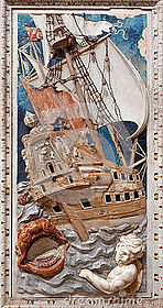
Piazza Bellini, restricted to pedestrians, is quite close and is surrounded by three churches: La Martorana, San Cataldo, and Santa Caterina. Santa Caterina (1566), was closed for restorations so I could only visit the outside. Although the outside is restrained, the inside is supposed to be exuberant with deep red, blue and yellow mosaics in the Sicilian Baroque style. I would have loved to see the mosaic of Jonah being devoured by a whale with a Spanish galleon in full rigging (picture from web).
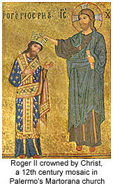
La Martorana (a word of Arabic origin) was commissioned in 1143 by George of Antioch, an Admiral in the fleet of King Roger II. Initially it was a celebration of Greek Orthodox Church but it became a Catholic church in the 13th century. I especially liked the Norman-Arab bell tower which looked like filigree and “lightened” the architecture.
The mosaics (many were destroyed) are amongst the most impressive ever to have been created in Sicily. The same artisans, brought from Byzantium by King Roger II), also worked on the Norman Palace and the Duomo at Cefalu’.


There were several tour groups in the church, many just sitting in the pews gazing in awe at the mosaics. They were amazing, many were recording historical events. To properly appreciate them I would have to read up on them ahead of time and seek them out. For example, A mosaic in the Martorana Church depicts Roger clad as a Byzantine monarch wearing a robe of golden crosses on a blue field, the earliest known representation of what eventually became the heraldic symbol of the French kings


But my favourite church was San Cataldo, with its three red domes which give it a Moorish look. It is a medieval church dating from mid-12th century and is now the main seat of the Knights of the Holy Sepulcher. Not only is it simple on the outside but also in the inside. When you walk in, you are struck by the soaring unadorned arches and plain stone ceiling. It is such a relief after the gilt ceilings in the Baroque churches. The central altar is also unusual, with only a suspended crucifix against the stone walls. Somehow, the austerity was much more powerful (to me) than the ostentatious gilt of the Baroque churches.


I then walked around the corner to the 16th century Piazza Pretoria featuring the (in) famous fountain originally built during the Inquisition for a Tuscan villa. It is considered the most beautiful fountain in Italy. Because it features sixteen nude statues of nymphs, humans, mermaids and satyrs it is also known as the “fountain of shame”.

You can also see on the right the large dome (decorated with yellow and blue majolica tiles) of another outstanding Sicilian church, San Giuseppi dei Teatini. One of the guide books had excellent advice: if you are not a fan of the Baroque avoid it, because it is one of the best examples of the genre. However, I did peek in.

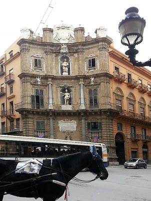
Around the corner where the two main streets meet (Via Maqueda and Via Vittorio Emanuele) is junction of the old Palermo center – the “Quatro Canti”. The Spanish Viceroy commissioned them in 1611 and the four corners depict a variety of themes involving the number 4: the four seasons(at street level), four Spanish kings (the middle level), four patron saints (top level).
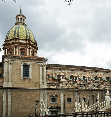
From there I walked up Via Vittorio Emanuele to the Duomo, another Baroque church built on the site of a Byzantine church founded by St. Gregory and converted to a mosque in the 9th century. The cathedral has a heliometer (solar observatory), built in 1690, which consists of a pinhole camera projecting an image of the sun on a bronze line on the floor (the meridiana) at solar noon in summer (12:00) and solar noon in winter (13:00). I guess we did not invent daylight saving time. Along the line are the signs of the zodiac, showing other dates of the year. I find this wonderful, linking it to the practices in the megalithic temples. I will have to go back and study these more.
The current church was built by the Anglo- Norman archbishop of Palermo in 1185; however, it has been extensively modified over the centuries. I was pleasantly surprised when I entered the church in that it was much less ornate than the other churches, perhaps reflecting its medieval origins. Several kings and queens are buried here (Frederick II and his wife Constance of Aragon, her brother Peter II of Aragon, and empress Constance d'Altavilla, daughter of Roger II and mother of Federico II). I find I know little of this era of European history so will have to bone up when I get to Montreal. There are some beautiful art work, mosaics, and treasures, which stand out against the relatively plain interior. I especially loved the statues which (to me) had an “ancient Greek” look.


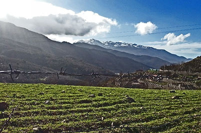
Luigi had told me I should really try to see more of the Madonie Park, so I got up early (despite the cloudy day) and drove towards the mountain towns of Gratterie, Castelbuono and Geraci Siculo. The Madonie include Pizzo Carbonara (1979 meters) which is the highest point in Sicily after Mount Etna. It was snow covered in December and visible from Palermo. Many peaks were still snow covered in late March; but everyone tells me this was an unusually wet cold winter. On some roads you are required to have snow tires or chains from November 30th to April 15th (more than at home).
Many of the mountain towns date from the 9th century and were founded by the Saracens built upon the remains of Sicanian, Greek and Roman settlements. They were subsequently enlarged by the Normans. The Madonie region extends, between the towns of Scillato and Castelbuono, from the Pollina to the Imera rivers, reaching down to coastal Cefalù.
The land is lightly wooded with chestnuts, giant holly (some over three hundred years old), wild olives (oleasters), flowering Manna Ash (Fraxinus Ornus), and the extremely rare local variety of Sicilian Fir (Abies Nebrodensis). The entire population consists of 30 trees and it is considered the rarest Christmas tree in the world. Foxes, hares, porcupines, re-introduced deer, and a few wild cats roam these mountains. Eagles and hawks soar overhead.


Gratterie is quite close to where I am staying so I drove there to gas up. People were beginning to work in the fields, burning the debris from the winter. The air smelled of wood smoke and wild flowers. There were rivulets of water from the melting snow on the mountains. It very much felt like late spring in the Eastern Townships, except that the mountains were much more rugged.
Gratteri has a population of about 1,300 and recently has attracted foreign residents because of its panoramic view of the Tyrrhenian coast and the Madonie Mountains. As you approach Gratterie, you first notice the cluster of “modern” houses with red tiled roofs. As you get closer you can see that many are older stone houses that have been renovated. There are several narrow winding streets through the town with cafes and restaurants.


It was inhabited in the late Bronze Age or early Iron Age and appears to have been a trading center connecting coastal and mountain populations. Although probably founded by the Romans, the town clearly shows Arab-Medieval features. It was captured from the Saracens by Count Roger and passed to the Princes Ventimiglia di Geraci and Castelbuono (more about them later).
I stopped for gas at the station on the outskirts of the town and spent a half hour talking to the gas attendant. He had gone to Toronto and Niagara Falls for his honeymoon so he was very glad to talk to me. He said many young people from the area had to leave (many went to Toronto) to find work. However, many came back when they had accumulated enough money to live here. He was fascinated by native people and asked how Canada treated them. He was the third person to ask me directly. It seems there was a TV documentary about an Italian construction company that had refused to dig up an aboriginal graveyard to build an observatory. They argued that the observatory could be built somewhere else and not disrupt the graveyard. This is from a country that is “littered” with necropolis.
The mountain road wound its way to a crossroad (SP136) to Isnello, a quaint Sicilian holiday resort clinging to the rock in the middle of a gorge surrounded by high limestone walls. The caves around Isnello have been inhabited since prehistoric times. Like the other towns in the Madonie, it was founded by the Arabs in the middle Ages on a former Greek settlement. It now is the centre for trekking in the surrounding mountains and has many cafes along narrow roads.

I then took SP 9 to visit the castles in Castelbuono and Geraci Siculo. The road was spectacular with almost continuous switch-backs. My GPS lady got “dizzy” and kept saying “route recalculation”. My shoulders got really sore (the SMART does NOT have power steering). There were sheep, horses, and cows wandering at will on the roads. I think they use them to crop the grass in the verges. They all wear bells and you constantly hear them tinkle so can slow down (not that you are going too fast, anyway). The views from the towns are wonderful with receding green mountains in front and rocky (snow-covered) crags behind them. It is very different from the sunny, sandy beaches at the sea front.


When I got to the outskirts of Castelbuono, I saw a herd of donkeys by the side of the road, so maybe it is true that they use them to pick up the garbage. They would have a much easier time navigating the narrow steep stone roads. I had a cappuccino with my favourite barista and then went to the 14th century Castel. Count Ventimiglia (whose family controlled this area for 2 centuries, built the castle on the ruins of the Byzantine town Ypsigro. It is a mixture of styles added over the centuries: the Arabic cube shape, the square towers and the battlements of the Norman style, and the Swavian round tower. Apparently you can visit it and see the treasures of the Ventimiglia. The castle is at the top of the hill so you can see it for miles. You can also see the steeple of the main church the Cheisa Madrice Vecchia, erected in the 15th century on the remains of a pagan temple. I did not go in because I was much more fascinated by the view of the mountains and rooftops.


The Ventimiglia family also built a castle in Geraci Siculo (30 minutes away from Castelbuono up the SS 286). The road is all switchbacks even in the town with very steep roads leading to the castle and community library. The Castel at the very top of the town is in the process of being restored. It sits at the top of a cliff amidst wildflowers and scented pines. It is tranquil, picturesque with 360o views of the surrounding mountains.


I had wanted to drive all the way around the park to the south side and visit the other Madonai towns: Petrano Soprana, Petralia Sottana, and Gangi, but it was getting late so I returned to the house. The drive back was lovely through the mountains with only cows, horses, and sheep on the road.
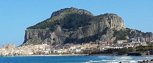
Today the sun was shining and a perfect day to climb Rocca to the Megalithic structure, attributed to the Sicani, known as the Temple of Diana. The “Rocca” is a calcareous outcrop 270 meters above sea level. It is very richly fossilized with snails and in the past has been prized as building material. It was used for the baptismal font in the cathedral and for the base of Frederick II’s tomb. It was also used to build parts of the Temple of Diana. There are limestone caves below the rock, the largest (La Grotta del Cancello), being over 400 meters deep. After the fall of the Roman Empire, the population of Cefalu abandoned the seaside town and moved to the top of the Rocca for protection against the Arabs and pirates. There are remains of the fortifications, houses, bread ovens, store houses, as well as cisterns.

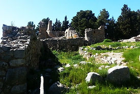

There are the remains of a 12th century church dedicated to St. Anna. Further up, there is a dolman-type cistern dating from the 9th century BC, used for the worship of waters. Here is where you find the Temple of Diana, dating from the 5th century BC. Here is a picture of the Rocca, with the Cathedral in the center of the town at its base, from the Cefalu Beach to give you a sense of perspective.

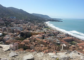
I first stopped in Cefalu for my morning cappuccino and asked the waitress where to begin the climb. She told me there were steps across the street leading to the Rocca Park entrance. I don’t know if it is an omen that the steps were called San Giuseppe, my grandfather's name. She also told me that I could park in front of the coffee bar. So I walked up these narrow lanes and was already tired when I got to the ticket booth. The ticket agent, seeing my cane, asked me if I was sure that I could walk to the top. When I said that I would try, he said he would charge me half price (you have to love Sicilians - they are so human). He also said the climb usually takes 20 minutes but that it might take me 30 minutes. Well he lied as did all the guide books. It took me well over two hours as it did for the other younger and fitter trekkers. I have NEVER done anything so physically difficult in my life. The first 1/3 of the trail consists of switchbacks on a rock pathway that is bordered by a metal railing. The views of Cefalu are stunning, and as you climb the houses get smaller and smaller.
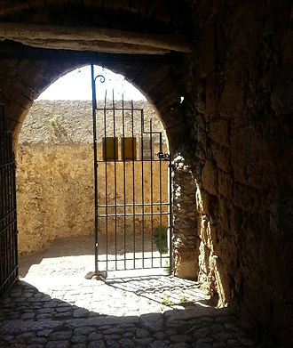
The metal railing is then replaced by a wooden railing that is loose (and dangerous to hold onto) for another third of the way. Then, there is no railing. You first walk (scramble and climb) along a narrow path skirting the walls. Apparently, attackers would have to carry their shield with their right arm and therefore could not attack. You then pass through a gate into the fortified citadel. You climb over rock strewn ground where there are water cisterns and the remains of houses.


When I got near the top I began to get dizzy, had black spots before my eyes and finally threw up (behind a bush off the path) from the exertion; but, I did get to the temple of Diana. From there you can go in three directions: to the top of the Rocca to the Saracen Castle, to the ramparts, or to the Temple of Diana.


There were quite a few people taking the trek: a very fit German couple, an Oriental couple who gave me the high-five as we crossed paths, and a British family, who were taking a lot of rests in the shade of the fortifications. I first went to the ramparts where a couple seemed unconcerned that their son was running along the top of the ramparts. It is a shear drop over the cliffs. I then wandered south to the megalithic temple known as the Temple of Diana. This is considered to be a unique building because of its masonry: huge blocks of limestone (Cyclopian) are carefully joined together. Crude moldings similar to those of the Doric order are hewn on the face of the massive blocks. I am glad that I climbed the Rocca but I wouldn’t do it again. I then drove home, taking another small road and admiring the villas perched over the sea.
I had visited the northern boundary of the Madonai Regional Nature Park (I am in fact staying in a house in the Park) so I decided to try and go to the southern boundary. As you can see the area is quite large and includes several high peaks which still had snow. I have to go through Castelbuono but I decided to take a different route, east along the SS113 (instead of through Isnello) and then pick up the SS286 to Castelbuono and Geraci Siculo to Monte di Corvo. I could then go west along the SP120 and visit the two Petralias (Soprana and Sottana), taking the small unmarked roads. The views of the Tyrrhenian and Cefalu were spectacular – to bad there was some haze. The side roads through the mountains were also scenic and no traffic (even livestock). I think this area is more alpine and is mainly used for mountain tourism.